Longitudinal Profile
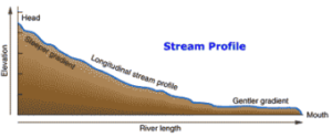
The plot of the relative elevation of a stream bed from headwaters to mouth is called its “longitudinal profile”. In other words, the longitudinal profiles are plots of the elevation vs distance from the stream mouth to the upper reaches within the watershed basin. The longitudinal profile of a stream is generally concave upward, which is in accordance with the steady downstream decrease in slope. They help to establish the relationship between slope steepness and distance from the upper to lower reaches. Slope or gradient can be measured in degree or percentage (rise over run).
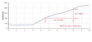
For example, the maximum elevation of a drainage basin is about 2000 m at the head and 200 at the mouth of the stream. The gradient of the stream can be determined by dividing the change in elevation between any two points (rise) by the distance between those two points (run).
Base Level
The level, which controls the depth of stream erosion is called a “base level”. As base level is the lower limit of the longitudinal profile, streams can not cut below this level. There are two types of the base levels: (i) ultimate base level and (ii) local base level. The “ultimate base level” represents the lowest level to which a stream can erode its valley. It is, therefore, the level at which the mouth of a stream enters a lake or the ocean. Resistant rock beds, waterfalls, lakes or artificial dams, which lie along a river course form “local base levels”. They act as limiting levels for the stretches that exist immediately upstream. Thus local base levels are temporary obstructions to down-cutting encountered by a stream.
Any change in base level causes a stream to change its characteristics. Lowering of base level increases the stream’s gradient. As a result, the velocities increase and down-cutting is increased. The erosion first starts from near the mouth and then works upstream until the stream profile is adjusted along its full length. Thus the bedrock channel is deepened and parts of the old valley floor are left as a terrace along the walls of the new valley. Such steps-like features are called “river terraces”.
Braided Stream
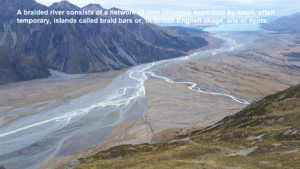
A rise in the base level reduces the stream sediment transporting capacity. As a result the stream deposits sediments thereby building up its channel. Sometimes the capacity of a loaded stream is lowered to such an extent that heavy aggradation takes place. Now the single river channel can no longer carry its load. In such circumstances, the individual channel subdivides itself into a series of smaller channels. These channels are separated by many low islands, which are the product of heavy deposition. Such a stream is called “braided stream”.
Profile of Equilibrium
Streams have tendency to cut and remove the material from high gradient regions and deposit it in the low gradient areas. In due course of time, when a uniform longitudinal slope is developed throughout the stream course, the process of erosion and deposition ceases. Such a slope is called the “profile of equilibrium” or graded profile” of a stream.
Thus a braided stream will not erode or deposit material but will, simply transport it. As a matter of fact, this stage is never reached due to many disturbances.