A natural drainage system refers to the network of flowing water. We can find flowing water in the form of rivers, streams, lakes, wetlands, and groundwater. This network of natural features manages the flow of water across the landscape. These systems are essential for transporting water from higher elevations to lower elevations, regulating the water cycle, replenishing groundwater supplies, supporting ecosystems, and preventing flooding.
Here’s a breakdown of the components of a natural drainage system:
- Rivers and Streams: These are the primary channels through which water flows across the land. They collect water from smaller streams and runoff from rain or melting snow, eventually emptying into larger bodies of water like lakes or oceans.
- Lakes: Lakes act as storage reservoirs for water. They receive water from rivers, streams, and precipitation, and they can release water back into the system during dry periods or when water levels are high.
- Wetlands: Wetlands are areas where water either covers the soil or is present near the surface. They play a crucial role in filtering pollutants, absorbing excess water during floods, and providing habitat for diverse plant and animal species.
- Groundwater: This refers to water that is stored beneath the Earth’s surface in saturated soils and rock layers called aquifers. Groundwater can feed into rivers and streams through springs, maintaining base flow during dry periods.
- Watersheds: A watershed is an area of land where all the water drains into a common outlet, such as a river, lake, or ocean. It’s like a natural bowl that collects and directs water flow.
A healthy natural drainage system is important for maintaining water quality, supporting biodiversity, and sustaining human activities like agriculture, industry, and recreation. Protecting and conserving these systems is essential for the well-being of both ecosystems and communities.
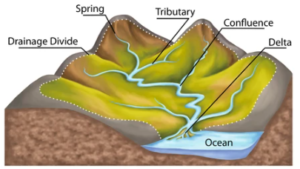
Components of the Drainage System
Spring
Spring in the context of a drainage system typically refers to a natural water source that emerges from the ground, often forming a small stream or creek. These springs can play important roles in drainage systems by replenishing groundwater, providing water for ecosystems, and contributing to surface water flow.
Confluence
Confluence is a point where two or more water channels meet and merge into one another to form a larger body of water. It is an important concept of hydrology, which helps to understand the river systems and their behavior. A confluence may be of three types;
- Tributary Confluence: This confluence comes into existence, when a smaller river (tributary) joins the larger one. The point at which the smaller water channel merges into the larger, is known as the tributor confluence.
- Parallel Confluence: A confluence formed as a result of merging of two streams of almost similar size. Two streams of similar size join together, often forming a “Y” shape.
- Angular Confluence: At an angular confluence two streams meet at an angle, forming a distinct point of convergence.
Drainage Basin
A land area surrounded by divides, which contributes water to a river, is called a “drainage basin”. It is also known as a watershed or catchment area, which is an area of land where all surface water from rain, melting snow, or ice converges to a single point, such as a river, lake, or ocean. This water then flows out of the basin via a single outlet, which could be a river mouth or a point where the water enters an underground aquifer.
Drainage basins are defined by natural topographic boundaries such as ridges, hills, and mountains. They can vary greatly in size, ranging from small ones that cover a few square kilometers to massive basins like the Mississippi River Basin, which spans millions of square kilometers across several states in the United States.
Divides
A drainage divide, also known as a water divide, is a high-ground ridge geographical feature that separates the drainage basins or watersheds of adjacent areas. Essentially, it’s the boundary line that determines which way water flows. When rain falls or snow melts, the resulting water either flows in one direction toward one watershed or in another direction toward a different watershed, depending on which side of the drainage divide it’s on. Divides range in size from a ridge separating two small gullies to “continental divides” which divide continents into large drainage basins.
For example, imagine a mountain ridge. If rain falls on one side of the ridge, it will flow down into streams and rivers that ultimately drain into one watershed. On the other side of the ridge, the water will flow into a different watershed. The ridge itself acts as the drainage divide, determining where the water goes.
Drainage divides are crucial in hydrology and geography because they help define the boundaries of river systems and watersheds. They also play a role in understanding how water moves across landscapes and how human activities can impact water quality and availability in different regions.
River Captures
“River Capture” is a process by which a part of the drainage of one river is diverted into another. Due to greater discharge, slope or other factors, the stream on one side of a divide may erode its valley more actively than the stream on the opposite side. While lengthening its valley headward, it may reach the less active river by breaking down the divide between the two and diverting a part or all of its drainage into its own channel. The river capture commonly occurs in the youth stage. It becomes less common as stream grows larger and is rare in large rivers.
Mouth of River
The mouth of the river/ stream is a place, where the river falls into a larger body of water. The large body of water may be an ocean, a larger, river, or a lake. At the river mouth, sediments are often accumulated due to the slowing of the current, reducing the carrying capacity of the water. At the mouth, the river often divides into smaller channels due to the decrease in slope.
Drainage Pattern
Although all drainage networks branch in the same way, the shape of their patterns varies greatly from one kind of terrain to another, depending upon the rock type or structure. The chief drainage pattern are: (i) dendritic, (ii) trellis, (iii) rectangular, (iv) radial, and (v) parallel.
- Dendritic Pattern: In a dendritic pattern, the streams show a branching tree-like arrangement. This pattern develops in terrains covered with uniform rock types, such as horizontal sedimentary rocks or massive igneous or metamorphic rocks.
- Trellis Pattern: A trellis pattern is one in which major streams are parallel and short tributaries join the mainstream at nearly right angles. This type of drainage pattern develops in regions containing folded or tilted strata. Here the main stream develops in the strike valleys cut into the soft rocks, while tributaries flow down the resistant ridges.
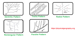
Five Major Types of Natural Drainage Patterns - Rectangular Patterns: Differential weathering of faults or joint systems in bedrock localizes the stream flow producing a more ordered rectangular drainage. In a rectangular drainage pattern, the angular deflections of stream courses are apparent.
- Radial Pattern: In a “radial drainage pattern” streams flow outward in different directions from a central high point. This pattern commonly develops on an elevated structure such as a volcano or dome.
- Parallel Pattern: This type of drainage pattern develops in a terrain containing tilted bedrock and parallel faults. The major stream occupies the main fault, while the tributaries (which are parallel) meet the stream approximately at the same angle.