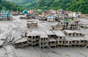
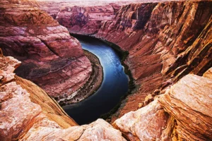

The Atmosphere is another vital component studied in physical geography, referring to the layer of gases — mainly nitrogen, oxygen, carbon dioxide, and water vapor — that surrounds the Earth and is held in place by gravity. Within this component, geographers study the atmosphere’s structure, which is divided into layers such as the troposphere, stratosphere, mesosphere, thermosphere, and exosphere, each with distinct characteristics and functions, like the ozone layer in the stratosphere that protects life from harmful UV radiation. A major focus is on weather, the short-term atmospheric conditions like temperature, humidity, and precipitation at a given place and time, as well as climate, the long-term weather pattern of a region shaped by factors such as latitude, altitude, and proximity to oceans. The study also covers temperature and heat balance, explaining how uneven solar heating creates variations between the equator and poles, and air pressure and wind systems, which explain the formation of global wind belts and seasonal winds like monsoons. Additionally, it examines humidity and precipitation, looking at how moisture in the air leads to rain, snow, or hail, and atmospheric phenomena such as cyclones, thunderstorms, and fog. In recent times, this component also addresses climate change and global warming, studying how human activities are altering atmospheric composition and disrupting natural weather patterns. Overall, the atmosphere component helps us understand the dynamic system of air that regulates Earth’s climate and sustains life on the planet.
Introduction to Physical Geography
Physical Geography Definition
Physical geography is the branch of geography concerned with studying the natural features and processes of the Earth’s surface. It focuses on understanding the physical environment — including landforms, climate, water bodies, soils, vegetation, and ecosystems — and explains how these elements form, change, and interact over time. For instance, physical geographers study how mountains rise through tectonic activity, how rivers carve valleys through erosion, why certain regions experience deserts while others have rainforests, and how climate patterns influence the distribution of plants and animals across the globe. Essentially, it seeks to answer how and why natural phenomena occur and are distributed the way they are on Earth’s surface. This makes physical geography different from human geography, which instead focuses on how people interact with, modify, and are influenced by these natural environments, such as through urbanization, agriculture, and resource use. Together, both branches form the broader field of geography, offering a complete picture of both the natural world and human activity within it.
What We Study in Physical Geography
Physical geography is made up of several interconnected components, each dealing with a specific part of the natural environment.
1. Lithosphere (Earth’s Crust/Landforms)
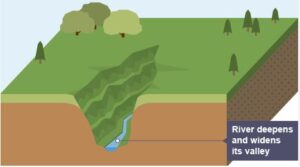
The Lithosphere is a key component studied in physical geography, referring to the solid, rocky outer layer of the Earth that includes the crust and the uppermost part of the mantle. Within this component, geographers study the internal structure of the Earth — its crust, mantle, and core — along with the different types of rocks (igneous, sedimentary, and metamorphic) and the rock cycle that transforms one type into another. A major focus is on landforms such as mountains, plateaus, plains, and valleys, and how they are created and shaped through processes like plate tectonics, which explains the movement of the Earth’s crust and its role in earthquakes, volcanic eruptions, and mountain formation. The lithosphere component also examines weathering, the breakdown of rocks in place, and erosion and deposition, where natural agents like water, wind, and ice wear away land in one location and deposit sediments in another, continuously reshaping the landscape. Additionally, it covers how weathered rock material eventually contributes to soil formation, supporting plant life and agriculture. Overall, the study of the lithosphere helps us understand the structure of the solid Earth and the dynamic natural forces — both internal and external — that continuously shape and transform its surface over time.
2. Atmosphere (Air & Climate)
3. Hydrosphere (Water Bodies)
The Hydrosphere is another essential component studied in physical geography, referring to all the water found on, above, and below the Earth’s surface, including oceans, seas, rivers, lakes, groundwater, and glaciers. Within this component, geographers study the water cycle (hydrological cycle), which explains the continuous movement of water between the atmosphere, land, and oceans through processes like evaporation, condensation, precipitation, and runoff. A major focus is on oceans and seas, which cover about 71% of the Earth’s surface, including their currents, tides, salinity, and role in regulating global climate. The study also covers rivers and streams, examining their formation, flow patterns, drainage systems, and the erosional and depositional work they perform in shaping landscapes like valleys and deltas. Additionally, it looks at lakes and wetlands, studying their formation and ecological importance, as well as groundwater, which includes the study of aquifers and the water stored beneath the Earth’s surface. The hydrosphere component also examines glaciers and ice caps, though these are sometimes studied separately under the cryosphere, along with their role in freshwater storage and sea-level changes. Overall, the study of the hydrosphere helps us understand the distribution, movement, and significance of water resources, which are vital for supporting ecosystems, agriculture, and human life across the planet.
4. Biosphere (Living Organisms)
The Biosphere is another key component studied in physical geography, referring to the zone of the Earth where life exists, encompassing all living organisms and their interactions with the atmosphere, hydrosphere, and lithosphere. Within this component, geographers study ecosystems, examining how plants, animals, and microorganisms interact with each other and their physical environment, forming both terrestrial ecosystems like forests and grasslands and aquatic ecosystems like marine and freshwater habitats. A major focus is on biomes, large-scale ecological zones such as tropical rainforests, deserts, and tundra, which are shaped primarily by climate and latitude. The study also covers the distribution of flora and fauna, exploring how plant and animal life vary across the globe based on temperature, rainfall, soil type, and habitat conditions. Additionally, it examines food chains and food webs, tracing the flow of energy from producers to consumers and decomposers within ecosystems, as well as biodiversity, highlighting the importance of variety in life forms for maintaining ecological balance. In modern contexts, this component also addresses human impact on the biosphere, studying how activities like deforestation, urbanization, and pollution disrupt ecosystems and contribute to habitat loss and species extinction, along with conservation efforts aimed at protecting biodiversity. Overall, the study of the biosphere helps us understand the living world and its intricate relationship with the physical environment, emphasizing the need for ecological balance and sustainable coexistence between humans and nature.
5. Pedosphere (Soil Layer)
The Pedosphere is another important component studied in physical geography, referring to the outermost layer of the Earth where soil forms, acting as the interface between the lithosphere, atmosphere, hydrosphere, and biosphere. Within this component, geographers study soil formation, examining how weathered rock material combines with organic matter, water, and air over time through processes influenced by climate, parent rock, topography, and living organisms. A major focus is on soil types and classification, exploring different soil categories such as alluvial, black, red, laterite, and desert soils, each with distinct properties suited to different regions and uses. The study also covers soil composition and structure, analyzing the proportions of minerals, organic matter, water, and air within soil, as well as its texture and layering into distinct horizons (topsoil, subsoil, and bedrock). Additionally, it examines soil fertility, looking at the nutrients and properties that make soil suitable for supporting plant growth and agriculture, along with soil erosion and degradation, studying how factors like deforestation, overgrazing, and improper farming practices lead to the loss of fertile topsoil. The pedosphere component also addresses soil conservation, exploring methods to protect and sustainably manage soil resources for long-term agricultural productivity. Overall, the study of the pedosphere helps us understand how soil forms, functions, and supports life, making it a critical foundation for agriculture, ecosystems, and human settlement.
6. Cryosphere (Ice & Snow)
The Cryosphere is the final key component studied in physical geography, referring to the frozen parts of the Earth’s surface, including glaciers, ice sheets, polar ice caps, sea ice, and permafrost. Within this component, geographers study glaciers, examining how they form from compacted snow over time and how they move, shaping landscapes through erosion and deposition to create features like valleys, moraines, and fjords. A major focus is on ice sheets and polar ice caps, particularly those covering Antarctica and Greenland, which store the majority of the Earth’s freshwater and play a crucial role in regulating global sea levels. The study also covers sea ice, exploring its formation and seasonal variation in polar oceans, and permafrost, the permanently frozen ground found in cold regions, which affects soil stability and vegetation growth. Additionally, this component examines the impact of climate change on the cryosphere, studying how rising global temperatures are causing glaciers and ice caps to melt, contributing to rising sea levels and disrupting ecosystems that depend on cold environments. Overall, the study of the cryosphere helps us understand the role of ice and snow in regulating Earth’s climate, freshwater supply, and sea levels, highlighting its sensitivity to global warming and its far-reaching effects on the planet.
Why Physical Geography is Important to Study
Physical geography plays a crucial role in helping us understand the natural world and its impact on human life. Here’s why it matters:
1. Understanding Natural Processes
It helps us comprehend how natural phenomena like earthquakes, volcanic eruptions, floods, and cyclones occur, enabling better prediction and preparedness for natural disasters.
2. Resource Management
Knowledge of landforms, soils, water bodies, and climate helps in the sustainable use and management of natural resources like water, minerals, and fertile land, which are essential for agriculture and industry.
3. Environmental Conservation
Studying ecosystems, biodiversity, and climate patterns helps identify environmental problems like deforestation, pollution, and habitat loss, guiding conservation efforts to protect the planet.
4. Climate Change Awareness
Physical geography provides insight into climate systems, helping us understand the causes and effects of climate change and global warming, and supporting efforts to mitigate their impact.
5. Disaster Risk Reduction
By understanding physical processes like plate tectonics, weather patterns, and hydrology, communities can better plan for and reduce the risks associated with natural hazards such as earthquakes, floods, and landslides.
6. Agriculture and Food Security
Knowledge of soil types, climate, and water availability is essential for effective farming practices, crop selection, and ensuring food security for growing populations.
7. Urban and Regional Planning
Understanding landforms, drainage patterns, and natural hazards helps in planning cities, infrastructure, and settlements in ways that are safe and sustainable.
8. Basis for Human Geography
Physical geography lays the foundation for understanding human geography, as human activities like agriculture, trade, and settlement patterns are often shaped by natural physical conditions.
9. Environmental Awareness and Sustainability
It fosters a deeper appreciation of the natural environment, encouraging responsible behavior toward nature and promoting sustainable development practices.
World’s Famous Physical Geographers
1. Alexander von Humboldt (1769–1859)
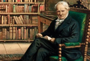
Alexander von Humboldt (1769–1859) was a German naturalist, explorer, and geographer widely regarded as one of the founding figures of modern physical geography and biogeography. Born in Berlin, Humboldt developed an early fascination with natural sciences and went on to conduct extensive explorations across Latin America, particularly in present-day Venezuela, Colombia, Ecuador, Peru, and Mexico, between 1799 and 1804. During these expeditions, he meticulously studied and documented volcanoes, rivers, mountains, climate patterns, and plant life, famously climbing Mount Chimborazo in the Andes to study how vegetation and climate change with altitude. This groundbreaking work led him to establish the concept of ecological zonation, demonstrating the interconnectedness between climate, altitude, and the distribution of plant and animal life — a foundational idea in biogeography. Humboldt was also among the first scientists to recognize the impact of human activity on the environment, warning about deforestation and its effects on local climates centuries before modern environmental science emerged. His most influential work, Kosmos, attempted to unify various branches of science into a holistic understanding of nature and the universe. Due to his immense contributions to earth sciences, ecology, and exploration, Humboldt is often referred to as the “father of modern geography”, and numerous places, species, and institutions around the world bear his name in honor of his legacy.
2. Carl Ritter (1779–1859)
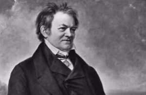
Carl Ritter (1779–1859) was a German geographer widely regarded, alongside Alexander von Humboldt, as one of the founders of modern geography. Born in Quedlinburg, Germany, Ritter dedicated his career to establishing geography as a systematic academic discipline, and he became the first person to hold a chair of geography at a German university, teaching at the University of Berlin for over three decades. Unlike Humboldt, who focused heavily on physical exploration and empirical observation, Ritter emphasized a more analytical and comparative approach, studying how the physical environment — landforms, climate, and natural resources — influenced human history, culture, and societal development. His major work, Die Erdkunde (The Science of the Earth), was an extensive multi-volume study that examined the relationship between geography and human civilization across different regions of the world. Ritter believed that geography should not merely describe the Earth’s features but explain the underlying connections between nature and human life, laying the groundwork for what would later develop into human and regional geography. His teleological approach, which viewed geography as revealing a divine order in nature, was influential in his time, though later geographers moved toward more empirical and scientific methods. Due to his pioneering role in shaping geography as an academic discipline and his focus on the human-environment relationship, Carl Ritter is remembered as one of the most influential figures in the history of geography.
3. William Morris Davis (1850–1934)
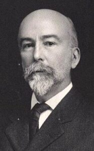
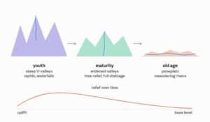
William Morris Davis (1850–1934) was an American geographer and geologist, widely known as the “father of American geography” for his foundational contributions to the discipline, particularly in the field of geomorphology. Born in Philadelphia, Davis spent much of his academic career at Harvard University, where he became a leading figure in establishing geography as a scientific field of study in the United States. His most significant contribution was the development of the “Geographical Cycle”, also known as the “Cycle of Erosion”, a theory explaining how landscapes evolve systematically over time through three progressive stages — youth, maturity, and old age — driven by the continuous processes of uplift, erosion, and weathering. According to this model, landforms begin as rugged and steep (youth), gradually become more rounded and moderate (maturity), and eventually erode into low, flat plains known as a “peneplain” (old age), unless renewed by tectonic uplift. Although later geographers criticized the model for oversimplifying the complexity of landscape evolution and not accounting for climatic variations, Davis’s cycle of erosion remained highly influential for decades and shaped the way geomorphologists studied and classified landforms. Beyond his theoretical work, Davis also played a key role in promoting geography education in American universities and helped found the Association of American Geographers in 1904. Due to his lasting impact on geomorphology and his efforts to establish geography as an academic discipline in the U.S., William Morris Davis remains a central figure in the history of physical geography.
4. Friedrich Ratzel (1844–1904)
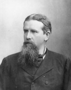
Friedrich Ratzel (1844–1904) was a German geographer and ethnographer best known for his pioneering contributions to human geography, political geography, and biogeography. Born in Karlsruhe, Germany, Ratzel initially trained in zoology before shifting his focus to geography, which allowed him to bring a strong biological perspective to his geographical theories. He is most famous for developing the concept of “Lebensraum” (meaning “living space”), which proposed that states, like living organisms, need sufficient territory and resources to grow and survive — a theory that examined the relationship between political states and their physical environment. This organic theory of the state viewed nations as living entities that expand or contract based on their environmental and geographical conditions, influencing the field of political geography significantly. Ratzel was also a key figure in the development of anthropogeography, the study of how physical environments shape human societies, cultures, and migration patterns, which he explored in his major work, Anthropogeographie. While his theories on Lebensraum were later controversially adopted and distorted by Nazi Germany to justify territorial expansion, Ratzel’s original academic work focused on understanding the genuine interplay between geography, environment, and human development rather than promoting aggressive expansionism. Despite this controversial legacy, Friedrich Ratzel remains an important figure in the history of geography for his foundational role in linking physical environments with human and political geography.
5. Vladimir Köppen (1846–1940)
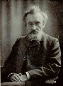
Vladimir (Wladimir) Köppen (1846–1940) was a German-Russian climatologist, geographer, and botanist best known for developing the Köppen Climate Classification System, one of the most widely used systems for classifying the world’s climates. Born in Saint Petersburg, Russia, to German parents, Köppen combined his expertise in botany and meteorology to create a classification system that grouped climates based on temperature and precipitation patterns, closely linking climate zones to the natural vegetation they support. First introduced in 1884 and refined over several decades, his system divided the world’s climates into five major types — tropical, dry, temperate, continental, and polar — each further divided into subtypes based on seasonal variations in temperature and rainfall. This approach was groundbreaking because it connected climatology directly with biogeography, recognizing that vegetation patterns could serve as reliable indicators of climate conditions. Köppen continued to refine his classification system throughout his career, and it was later expanded by climatologist Rudolf Geiger, resulting in the widely used Köppen-Geiger Climate Classification System that remains a standard reference in climatology, geography, and environmental science today. Beyond his climate classification work, Köppen also contributed to the study of paleoclimatology and collaborated with his son-in-law, Alfred Wegener, on research related to past climates and continental drift. Due to the lasting impact and widespread use of his climate classification system, Vladimir Köppen is remembered as one of the most influential figures in the history of climatology and physical geography.
6. Alfred Wegener (1880–1930)
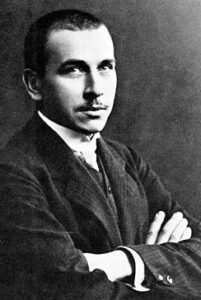
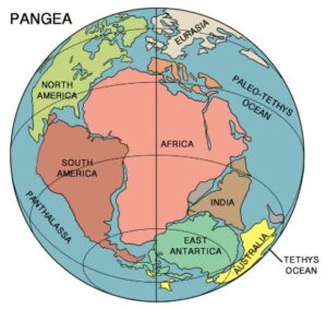
Alfred Wegener (1880–1930) was a German geophysicist, meteorologist, and polar researcher best known for proposing the groundbreaking theory of continental drift, which reshaped our understanding of Earth’s geological history. Born in Berlin, Wegener initially trained in astronomy but soon turned his focus to meteorology and geophysics, participating in several expeditions to Greenland to study polar air circulation and ice cap behavior. In 1912, he introduced his theory that all continents were once united in a single supercontinent, which he named “Pangaea,” and had gradually drifted apart over millions of years to form their present-day positions. Wegener supported this idea with evidence such as the matching shapes of coastlines, similar rock layers and fossils found on continents now separated by vast oceans, and corresponding ancient climate patterns across distant regions. Despite this strong evidence, his theory faced significant resistance and skepticism from the scientific community during his lifetime, largely because he could not explain the exact mechanism causing the continents to move. It wasn’t until decades later, with the discovery of seafloor spreading and the emergence of the theory of plate tectonics in the 1960s, that Wegener’s ideas were finally validated and recognized as revolutionary. Tragically, he died in 1930 during a research expedition in Greenland while studying ice cap conditions. Today, Alfred Wegener is honored as a pioneering figure in earth sciences, with his theory of continental drift regarded as one of the most significant scientific breakthroughs in the history of geology and physical geography.
7. Arthur Holmes (1890–1965)
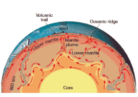
Arthur Holmes (1890–1965) was a British geologist widely recognized for his pioneering contributions to geochronology and his crucial role in providing scientific support for the theory of continental drift. Born in Gainford, England, Holmes developed an early interest in geology and made a groundbreaking contribution by using radioactive decay to accurately determine the age of rocks, effectively founding the field of geochronology and helping establish a much more precise geological timescale than previously possible. While Alfred Wegener’s theory of continental drift lacked a convincing explanation for what force could move entire continents, Holmes proposed a solution by suggesting the existence of mantle convection currents — a process where heat generated within the Earth causes slow, circulating movements of molten rock in the mantle, which could theoretically be strong enough to move continents over time. This idea, introduced in the 1930s, provided a plausible mechanism for continental movement decades before the concept of plate tectonics was fully developed and accepted in the 1960s. Holmes detailed his theories and broader geological knowledge in his influential textbook, Principles of Physical Geology, which became a standard reference for generations of geology students. Due to his foundational work in radiometric dating and his early insight into mantle convection as a driving force behind continental drift, Arthur Holmes is regarded as one of the most important figures in 20th-century geology, bridging the gap between Wegener’s original theory and the modern understanding of plate tectonics.
8. Halford Mackinder (1861–1947)
Halford Mackinder (1861–1947) was a British geographer, academic, and politician widely regarded as one of the founding figures of modern geopolitics and political geography. Born in Gainsborough, England, Mackinder played a key role in establishing geography as a serious academic discipline in Britain, helping found the School of Geography at the University of Oxford and later serving as the director of the London School of Economics. He is most famous for developing the “Heartland Theory”, first presented in his influential 1904 paper “The Geographical Pivot of History,” which argued that the vast interior region of Eurasia — which he termed the “Heartland” — held immense strategic importance due to its resources and central location, making it a key to global political power. Mackinder famously summarized his theory with the statement that whoever controls Eastern Europe commands the Heartland, whoever controls the Heartland commands the World-Island (Europe, Asia, and Africa combined), and whoever controls the World-Island commands the world. This theory linked physical geography — including landforms, resources, and location — directly to global political strategy and power dynamics, laying the foundation for the field of geopolitics. Mackinder’s ideas significantly influenced military and political strategy throughout the 20th century, particularly during both World Wars and the Cold War, as major powers sought to control key geographical regions outlined in his theory. Due to his pioneering integration of physical geography with political strategy, Halford Mackinder remains a highly influential figure in the history of geography, particularly within the field of political and strategic geography.
9. Wladimir Köppen & Rudolf Geiger
Wladimir Köppen and Rudolf Geiger are jointly recognized for developing and refining the Köppen-Geiger Climate Classification System, one of the most widely used climate classification frameworks in the world today. Wladimir Köppen (1846–1940), a German-Russian climatologist, originally created the foundational climate classification system in 1884, categorizing the world’s climates based on temperature and precipitation patterns linked closely to natural vegetation zones. After Köppen’s initial development and subsequent revisions of the system over several decades, German climatologist Rudolf Geiger (1894–1981), who had worked closely with Köppen, took on the responsibility of further refining and updating the classification system following Köppen’s death. Geiger improved the system’s accuracy and expanded its detail, incorporating more precise climate boundaries and updated data, which led to the system being renamed the Köppen-Geiger Climate Classification. This collaborative and evolving system divides global climates into five main categories — tropical, dry, temperate, continental, and polar — with further subdivisions based on specific temperature and precipitation characteristics. Due to its scientific accuracy, practicality, and continued relevance, the Köppen-Geiger system remains a standard tool in climatology, geography, and environmental science, widely used for climate research, agricultural planning, and ecological studies. The combined contributions of Köppen and Geiger have left a lasting legacy, making their classification system one of the most enduring and essential frameworks for understanding global climate patterns.
10. Jean Baptiste Lamarck (1744–1829)
Jean-Baptiste Lamarck (1744–1829) was a French naturalist and biologist best known for his early theories on evolution and his contributions to the classification of living organisms, which indirectly influenced the development of biogeography within physical geography. Born in Bazentin, France, Lamarck initially served in the military before shifting his focus to botany and later zoology, eventually becoming a prominent figure at the National Museum of Natural History in Paris. He is most famous for proposing one of the first comprehensive theories of biological evolution, known as Lamarckism or the theory of inheritance of acquired characteristics, which suggested that organisms could pass on physical traits developed during their lifetime — through use or disuse — to their offspring. Although this specific mechanism of evolution was later disproven and replaced by Darwin’s theory of natural selection, Lamarck’s broader idea that species change over time in response to their environment was a groundbreaking concept that challenged the prevailing belief in the fixed, unchanging nature of species. His work emphasized the deep connection between living organisms and their physical environment, highlighting how environmental factors could influence the development and distribution of species — a concept that became foundational to the later field of biogeography. Additionally, Lamarck contributed significantly to the classification of invertebrates and coined the term “biology” to describe the scientific study of life. Despite the eventual rejection of his specific evolutionary mechanism, Jean-Baptiste Lamarck remains an important historical figure whose early ideas on species adaptation and environmental influence laid important groundwork for the fields of evolutionary biology and biogeography.
Posts You May Like: