
What is The Ring of Fire?
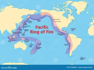
The ring of fire, also known as the Pacific Ring of Fire, The Rim of Fire, The Circum-Pacific Belt, or The Girdle of Fire, is a belt (tectonic) of volcanoes, and earthquakes. This belt is about 40,000 kilomete long spread upto about a width of 500 kilometer. This string is a sensitive site of seismic activities, and possesses thousands of volcanoes. Roughly 90% of the world’s earthquakes occur on this belt.
The Ring of Fire contains 750 to 915 active or dormant volcanoes, which is around two-thirds of the world’s total volcanoes. The exact number of volcanoes within the Ring of Fire depends on which regions are included. About 90% of the world’s earthquakes, including most of its largest, occur within this belt.
The Pacific Ring of Fire is not a single geological structure. It came into existence by the subduction of different tectonic plates at convergent boundaries around the Pacific Ocean. These subducted plates include the:
- Antarctic, Nazca and Cocos plates, which were subducted beneath the South American plate
- Pacific and Juan de Fuca plates, which were merged beneath the North American plate
- Philippine plate, which intruded beneath the Eurasian plate
- A complex boundary between the Pacific and Australian plates.
The interactions at these plate boundaries have formed very large oceanic trenches, volcanic arcs, back-arc basins and volcanic belts. The inclusion of some areas in the Ring of Fire, such as the Antarctic Peninsula and western Indonesia, is disputed.
The Ring of Fire has existed for more than 35 million years. But the presence of much older extinct volcanoes in some areas is an evidence that the subduction has existed for much longer in some parts of the Ring. More than 350 of the Ring of Fire’s volcanoes have been active in historical times, while the four largest volcanic eruptions on Earth in the Holocene epoch all occurred at volcanoes in the Ring of Fire.
Most of Earth’s active volcanoes with summits above sea level are located in the Ring of Fire. Many of these subaerial volcanoes are stratovolcanoes (e.g. Mount St. Helens), formed by explosive eruptions of tephra alternating with effusive eruptions of lava flows. Lavas at the Ring of Fire’s stratovolcanoes are mainly andesite and basaltic andesite, but dacite, rhyolite, basalt and some other rarer types also occur. Other types of volcano are also found in the Ring of Fire, such as subaerial shield volcanoes (e.g. Plosky Tolbachik), and submarine seamounts (e.g. Monowai)olcanoes (e.g. Mount St. Helens), formed by explosive eruptions of tephra alternating with effusive eruptions of lava flows. Lavas at the Ring of Fire’s stratovolcanoes are mainly andesite and basaltic andesite but dacite, rhyolite, basalt and some other rarer types also occur. Other types of volcano are also found in the Ring of Fire, such as subaerial shield volcanoes (e.g. Plosky Tolbachik), and submarine seamount (e.g. Monowai).
Where is the Ring of Fire?
Actually, the Ring of Fire is an elevated arc of mountains, volcanoes, and oceanic trenches that stretch from New Zealand northward along the eastern edge of Asia, then east across the Aleutian Islands of Alaska, and then south along the western coasts of North and South America.
Key Locations:
- Aleutian Arc: This is the zone where the Pacific Plate subducts under the North American Plate.
- Cascadia Subduction Zone: The zone at the coast of Cascadia that ranges from Northern California to Vancouver Island in Canada.
- Mexican Volcanic Belt: Also known as the Tans-Mexican Belt, Transvolcanic Belt and locally as the Sierra Nevada, where the Cocos Plate subducts under the North American Plate. It is an active volcanic belt that covers central-southern Mexico.
- Central America: Multiple subduction zones where the Cocos and Nazca plates dive under the Caribbean Plate.
- Andes: Formed by the subduction of the Nazca Plate beneath the South American Plate.
- Philippines, Indonesia, and the Melanesian Arc: Where several plates, including the Philippine Sea Plate and the Australian Plate, interact.
Countries Located Along the Ring of Fire
The number of countries along the Ring of Fire varies depending on how strictly you define the region. Estimates range from 15 to 22 countries. Here are some of the most commonly included countries:
- North America: United States, Canada
- Central America: Mexico, Guatemala, Costa Rica, Panama, Nicaragua
- South America: Chile, Peru, Ecuador, Colombia
- Asia: Russia (Kamchatka Peninsula), Japan, Philippines
- Oceania: Indonesia, Papua New Guinea, New Zealand
Historical Background of the Pacific Ring of Fire
The “historical background” of the Ring of Fire really has two layers worth unpacking: the deep geological history of how the region formed over hundreds of millions of years, and the more recent history of how humans came to recognize and understand it as a unified system. Both are worth walking through.
Deep time: the Pangaea connection
The story of the Ring of Fire’s formation stretches back roughly 250-300 million years, to a period when nearly all of Earth’s landmasses were fused into a single supercontinent called Pangaea, surrounded by one vast global ocean called Panthalassa — the ancestor of today’s Pacific Ocean. Even then, subduction zones existed around the margins of Panthalassa, meaning the basic process that drives the Ring of Fire today was already underway in some form. When Pangaea began breaking apart around 200 million years ago during the Mesozoic Era, its fragments drifted outward in different directions, and as they moved, the Panthalassic Ocean gradually shrank and reshaped itself into the modern Pacific. Crucially, as the continents split and rearranged, the boundaries between the Pacific’s oceanic plates and the surrounding continental plates became increasingly defined as convergent zones — places where dense oceanic crust was forced beneath the lighter continental plates. This slow, continuous rearrangement over tens of millions of years is what gradually built the subduction network that outlines the Pacific today.
Building the arcs, one collision at a time
As these subduction zones matured over the following geological eras, they began producing the volcanic mountain chains and island arcs that now define the Ring. The Andes, for example, have been building for roughly 200 million years as the oceanic Nazca Plate has subducted beneath the South American continental plate in a long, largely continuous process. Japan’s volcanic arc formed somewhat differently — it began as part of the Asian continental margin and was gradually rifted away starting around 15-20 million years ago, opening up the Sea of Japan behind it and leaving the Japanese islands as a separate arc shaped by subduction of the Pacific and Philippine Sea plates. The Aleutian Islands, the Cascade Range, and the volcanic arcs of Indonesia and the Philippines all have their own distinct timelines, but they share the same underlying mechanism, each one a record of subduction operating over immense stretches of geological time. This is why the Ring of Fire isn’t uniform in age — some segments are far older than others, and the belt as a coherent global feature is really an accumulation of many separate, overlapping histories rather than one single event.
The more recent chapter: shaping continents and civilizations
Even within human history, the Ring’s activity has repeatedly intersected with the story of civilizations living along its edges. Ancient peoples in Japan, Indonesia, the Philippines, and the Andes developed mythologies and belief systems around volcanic and seismic activity long before there was any scientific framework to explain it — Japanese folklore attributed earthquakes to a giant catfish (Namazu) thrashing beneath the islands, while various Andean and Indonesian cultures wove volcanoes into creation myths and deities requiring appeasement. These weren’t idle stories; they reflect just how routinely these societies experienced the consequences of living atop an active plate margin, from the 1883 eruption of Krakatoa in Indonesia, one of the most devastating volcanic events in recorded history, to the countless earthquakes that have repeatedly reshaped cities in Japan, Chile, and the Philippines.
The history of understanding it as a system
The idea of the “Ring of Fire” as a single, connected geological feature is actually a fairly modern one. Before the mid-20th century, earthquakes and volcanoes around the Pacific were generally studied as isolated regional phenomena rather than as expressions of one underlying global process. That changed with the development of plate tectonic theory in the 1960s, building on earlier ideas like Alfred Wegener’s continental drift hypothesis from the 1910s, which had been largely dismissed for decades because Wegener couldn’t explain what force was moving the continents. It wasn’t until oceanographic research in the mid-20th century — particularly the discovery of seafloor spreading at mid-ocean ridges — that scientists like Harry Hess and others pieced together the mechanism of subduction and plate movement. Once plate tectonics became the accepted framework, geologists could finally explain why earthquakes and volcanoes cluster so heavily around the Pacific’s margins: they aren’t scattered coincidences but the direct, visible signature of plate boundaries. The term “Ring of Fire” itself became popularized in the 20th century as this understanding spread beyond scientific circles and into general use, giving a memorable name to a pattern that geologists had only recently learned to explain scientifically, even though the physical belt itself had been forming for hundreds of millions of years before anyone had a word for it.
How the Ring of Fire Came into Existence?
The Ring of Fire wasn’t created in a single event — it’s the product of hundreds of millions of years of tectonic plate movement, and understanding it means starting with the basic structure of the Earth itself.
The foundation: a fractured shell
Earth’s outer layer, the lithosphere, isn’t one continuous piece. It’s broken into roughly 15-20 major and minor tectonic plates that float atop the semi-molten, slowly flowing rock of the mantle beneath them. These plates are constantly in motion, driven by heat from the Earth’s core and convection currents in the mantle — imagine a pot of thick soup simmering on a stove, with the surface slowly churning as heat rises from below. The plates move only a few centimeters a year, about the speed your fingernails grow, but over millions of years that adds up to enormous displacement.
Why the Pacific specifically
The Pacific Ocean sits atop one enormous oceanic plate — the Pacific Plate — along with several smaller neighboring plates like the Juan de Fuca, Cocos, Nazca, and Philippine Sea plates. What makes the Pacific special is that it’s almost entirely ringed by convergent boundaries, meaning the Pacific Plate and its neighbors are colliding with the continental plates surrounding them (the North American, South American, Eurasian, and Australian plates, among others). This wasn’t always the case — the current arrangement is the result of the breakup of the supercontinent Pangaea beginning around 200 million years ago, which set plates on new collision courses that gradually formed the boundary pattern we see today.
The engine: subduction
When an oceanic plate collides with another plate, something has to give, because two solid slabs of rock can’t simply occupy the same space. Oceanic crust is denser than continental crust, so when they meet, the oceanic plate is forced downward beneath the other in a process called subduction. This creates a subduction zone — and it’s this process, repeated all around the Pacific’s margins, that built the Ring of Fire. As the descending plate sinks deeper into the mantle, it encounters increasing heat and pressure. Water trapped in the subducting rock is released, and this water lowers the melting point of the surrounding mantle rock, causing it to partially melt. That molten rock, being less dense than the solid rock around it, rises toward the surface — and where it breaks through, it forms volcanoes. Over millions of years, repeated eruptions along these subduction zones build entire chains of volcanoes, called volcanic arcs, running parallel to the boundary. Japan, the Aleutian Islands, the Cascades of the American Pacific Northwest, and the Andes are all volcanic arcs formed this exact way.
Not everywhere is the same type of boundary
While subduction dominates most of the Ring, the boundary type varies around its circumference, which is why the belt isn’t uniform. Along the California coast, for instance, the Pacific and North American plates mostly slide horizontally past each other along the San Andreas Fault — a transform boundary — which produces earthquakes but comparatively few volcanoes. In contrast, places like Indonesia and the Philippines sit at genuinely complex junctions where multiple plates converge, producing intense volcanic and seismic activity. This variation is also why earthquake and volcano patterns differ so much from one stretch of the Ring to another — Japan and Indonesia are volcanically hyperactive because of steep, fast subduction, while parts of the California coast are earthquake-prone but volcanically quieter.
An ongoing, unfinished process
Crucially, the Ring of Fire isn’t a finished structure sitting static on the map — it’s an active, ongoing process. The plates are still moving today at roughly the same slow pace that built the Ring in the first place, meaning the earthquakes and eruptions we witness now are simply the latest instalment in a process that’s been running continuously for tens of millions of years and will keep reshaping the Pacific’s margins long into the future.
Disasters Associated with Pacific Ring of Fire
The Pacific Ring of Fire is responsible for a wide range of natural disasters, and understanding them means looking at the main categories: earthquakes, volcanic eruptions, tsunamis, and the secondary hazards these trigger, like landslides and lahars.
Earthquakes
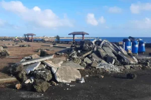
Because the Ring of Fire traces the boundaries where tectonic plates collide, slide past each other, or subduct beneath one another, it’s the most seismically active belt on the planet. Around 90% of the world’s earthquakes occur along this zone, ranging from minor tremors that go unnoticed to catastrophic megathrust quakes. Subduction zones are particularly dangerous because they can produce the largest earthquakes on Earth — when a subducting plate gets locked against the overriding plate for decades or centuries, enormous stress builds up until it releases all at once. The 1960 Valdivia earthquake in Chile, still the most powerful earthquake ever recorded at magnitude 9.5, occurred along this kind of subduction boundary. More recently, the 2011 Tōhoku earthquake in Japan, a magnitude 9.0, caused widespread destruction and triggered a cascade of secondary disasters. Countries like Japan, Chile, Indonesia, the Philippines, and the western United States live with a constant, elevated risk of major seismic events specifically because they sit along active convergent or transform boundaries.
Volcanic eruptions
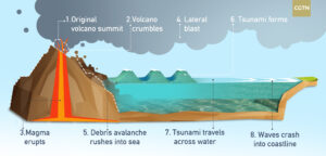
The Ring of Fire is home to roughly 75% of the world’s active and dormant volcanoes, a direct result of the subduction process that generates magma at converging plate boundaries. These eruptions vary enormously in scale and character. Some, like Hawaii’s volcanoes (which are actually hotspot volcanoes rather than subduction-driven, though nearby to the Ring), produce relatively gentle effusive lava flows. Others, particularly the subduction-zone volcanoes of Indonesia, Japan, the Philippines, and the Cascades, tend to be explosive because the magma involved is thicker and gas-rich, building pressure until it erupts violently. The 1883 eruption of Krakatoa in Indonesia killed over 36,000 people, largely through the tsunamis it generated, and altered global climate for years afterward. Mount Pinatubo’s 1991 eruption in the Philippines was the second-largest volcanic eruption of the 20th century, ejecting so much ash and sulfur dioxide into the atmosphere that it measurably cooled the planet for months. These eruptions can also produce pyroclastic flows — fast-moving currents of superheated gas and volcanic debris that can travel over 100 km/h and are almost unsurvivable for anyone in their path.
Tsunamis
Because so much of the Ring of Fire lies underwater or along coastlines, earthquakes and volcanic eruptions here frequently generate tsunamis, which are often the deadliest consequence of these events rather than the initial shaking or eruption itself. When a large subduction-zone earthquake causes a sudden vertical displacement of the seafloor, it can push an enormous volume of water upward, generating waves that travel across entire ocean basins at speeds comparable to a jet aircraft. The 2004 Indian Ocean tsunami, though technically originating just outside the traditional Ring of Fire boundary, illustrated this danger vividly, killing over 230,000 people across multiple countries. Within the Ring itself, the 2011 Tōhoku earthquake generated a tsunami with waves reaching over 40 meters in some areas, devastating Japan’s northeastern coast and causing the meltdown at the Fukushima Daiichi nuclear plant — a stark example of how a geological disaster can cascade into a technological and environmental one.
Secondary and compounding hazards
Beyond the primary disasters, the Ring of Fire generates a range of secondary hazards that often cause as much destruction as the initial event. Lahars — fast-moving mudflows made of volcanic ash, debris, and water — are among the deadliest, as they can occur even during relatively minor eruptions if a volcano is capped with snow or ice, or if heavy rain mixes with loose ash deposits. The 1985 Nevado del Ruiz eruption in Colombia (near enough to Ring of Fire dynamics in the Andes to be illustrative) triggered lahars that buried the town of Armero and killed over 23,000 people, despite the eruption itself being relatively modest. Earthquakes along the Ring also frequently trigger landslides in mountainous or hilly terrain, and can cause soil liquefaction in areas with loose, water-saturated ground, where the shaking causes solid-seeming earth to behave like a liquid, swallowing buildings and infrastructure. Volcanic ashfall, meanwhile, can collapse roofs, contaminate water supplies, disrupt air travel across entire regions, and damage crops and livestock over huge areas, even far from the eruption site itself.
Why the human toll is so significant
What makes the Ring of Fire particularly consequential isn’t just the frequency or intensity of these disasters, but the fact that some of the world’s most densely populated regions — Japan, Indonesia, the Philippines, and the western coasts of the Americas — sit directly on top of this active zone. Indonesia alone has over 130 active volcanoes and a population of hundreds of millions living in close proximity to them, meaning that even moderate seismic or volcanic events can carry an outsized human and economic cost.