
William Morris Davis
William Morris Davis (1850–1934) was an American geographer and geologist widely regarded as the founder of modern geomorphology. Born in Philadelphia, he taught for most of his career at Harvard University, where he trained a generation of geographers and helped establish geography as a rigorous academic discipline in the United States. Davis is best known for developing the geographical cycle of erosion (1899), a theory proposing that landscapes evolve through predictable stages—youth, maturity, and old age—as tectonic uplift is gradually worn down by erosion toward a low-relief peneplain. Beyond landform theory, he made lasting contributions to the study of river systems, coral reef formation, and the broader methodology of physical geography, emphasizing systematic, process-oriented explanation over purely descriptive accounts of landscape. Though his cyclical model was later challenged and largely superseded by process-based and quantitative approaches from figures like Walther Penck and Lester King, Davis’s work laid the conceptual groundwork for how geomorphologists think about the relationship between time, tectonics, and landform evolution, and he remains one of the most influential figures in the history of earth science.
Geographical Cycle (Cycle of Erosion) presented by William Morris Davis
William Morris Davis presented the Geographical Cycle, also known as the Cycle of Erosion, in 1899 as a unifying theory to explain how landscapes evolve over time. Davis proposed that landform development is a function of structure (underlying geology), process (erosional agents like rivers and weathering), and time, with time being the most important variable driving change. He argued that following a period of rapid tectonic uplift, a landmass undergoes progressive erosion through three sequential stages, described using an analogy to biological life: youth, marked by rapid downward river cutting, steep V-shaped valleys, and increasing relief; maturity, the stage of maximum relief where valleys widen, divides sharpen, and the drainage network becomes fully integrated; and old age, where relief is greatly reduced, rivers meander across broad floodplains, and the landscape is worn down to a low, gently undulating plain called a peneplain, occasionally interrupted by isolated resistant hills known as monadnocks. Davis also introduced the concept of rejuvenation, where renewed uplift could interrupt the cycle and cause rivers to re-incise into the landscape. Although the theory was highly influential in establishing geomorphology as a systematic discipline and introduced enduring terminology still used today, it was later criticized for its unrealistic assumptions about uninterrupted tectonic stability and its largely deductive, untestable nature, leading to the development of alternative models by geomorphologists such as Walther Penck and Lester King.
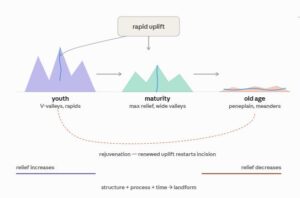
Key Concepts of the theory
Davis argued that landform development could be explained by a simple formula:
Landscape = f (Structure, Process, Time / Stage)
- Structure — the underlying geology (rock type, folding, faulting)
- Process — the erosional agents at work (rivers, weathering, mass wasting)
- Time (Stage) — how far along the erosional cycle the landscape has progressed
Davis borrowed the language of biological life stages — youth, maturity, old age — to describe landscape development, making the theory intuitive and easy to teach, even though it’s a deductive (theory-first) model rather than one built from field measurement. You may like to read: Stages of Valley Development
Cycle of Erosion
Starting Point of the Cycle
The cycle begins with rapid tectonic uplift of a landmass (or a newly exposed sea floor), followed by a long period of tectonic stability — Davis assumed uplift happens quickly and then erosion works uninterrupted for a very long time. This “uplift then wait” assumption is one of the theory’s most criticized aspects.
The Three Stages
1. Youth
- Rivers begin cutting rapidly downward (vertical erosion dominates)
- Valleys are steep-sided and V-shaped
- Waterfalls, rapids, and interlocking spurs are common
- Wide, flat interfluves (uneroded areas) remain between valleys
- Drainage network is poorly integrated; lakes and marshes may exist in undrained areas
- Relief is increasing
2. Maturity
- The stage of maximum relief and maximum landscape complexity
- Valleys widen as lateral (sideways) erosion becomes more important
- Divides between valleys are lowered and sharpened
- The whole landscape becomes fully dissected — no flat interfluve surfaces remain
- Drainage network is fully integrated and efficient
- Rivers begin to develop gentle gradients and slight meandering in their lower courses
3. Old Age
- Relief is drastically reduced
- Valleys are broad, shallow, and flat-floored
- Rivers meander widely across broad floodplains
- Divides are low and rounded
- The landscape approaches a peneplain — an almost featureless plain graded close to base level (sea level), with occasional isolated erosional remnants called monadnocks rising above the general surface
Rejuvenation
Davis also allowed for rejuvenation — renewed uplift or a fall in base level partway through the cycle — which causes rivers to re-incise into the landscape, producing features like incised meanders and river terraces. This let the model account for landscapes that don’t fit a “clean” single cycle.
Why It Was Influential?
William Morris Davis’s Geographical Cycle shaped the discipline of geomorphology in several important ways, even though many of its specific claims were later revised or rejected.
1. It created the first systematic framework for landscape study
Before Davis, landscape description was largely fragmented and observational. Davis gave geomorphologists a unifying, logical structure—structure, process, time—that connected geology, erosion, and time into a single explanatory model. This turned landform study into a more coherent, teachable science.
2. It established a lasting vocabulary
Terms Davis coined or popularized—youth, maturity, old age, peneplain, base level, rejuvenation, monadnock—became standard geomorphological language. Even today, some of these terms are used informally, even by geomorphologists who reject the cyclical theory itself.
3. It shaped geography as an academic discipline
Davis was instrumental in professionalizing physical geography in the United States. Through his position at Harvard and his role in founding the Association of American Geographers (1904), he trained and influenced a generation of geographers and geomorphologists who carried his ideas—and later their critiques of it—forward into the 20th century.
4. It provided a model that others could build on—by challenging it
Much of 20th-century geomorphology developed in direct response to Davis. Walther Penck reworked slope development around uplift/erosion rate ratios largely as a critique of Davis’s stage-based approach, while Lester King developed pediplanation theory to better explain semi-arid landscapes that didn’t fit Davis’s temperate-climate model. In this sense, Davis’s theory was influential precisely because it gave later scholars a clear, well-known target to refine, adapt, or oppose.
5. It encouraged large-scale, long-term thinking about landscapes
Davis pushed geomorphologists to think about landform evolution over geological timescales rather than treating landscapes as static. This long-term, evolutionary perspective—even if his specific “life-cycle” analogy was too simplistic—remains central to how geomorphologists think about landscape change today.
6. It influenced applied and regional geography
Davis’s model was widely used in early 20th-century regional geography and geological surveys to interpret and classify landscapes around the world, particularly in mapping erosion surfaces and reconstructing regional denudation histories.
In short, Davis’s lasting influence lies less in the literal accuracy of his three-stage cycle and more in the fact that he gave geomorphology its first organizing theory—one so influential that virtually all major theoretical developments in the field for the next several decades were formulated either in support of, or in reaction against, his ideas.
Why It Was Criticized
- Untestable timescales — a full cycle was assumed to take many millions of years, far beyond what could be observed or verified
- Unrealistic assumptions — real landscapes rarely experience uplift followed by long, uninterrupted tectonic stability
- Peneplains are rare — true, extensive peneplains are difficult to identify unambiguously in the field
- Too deductive — the model was built from armchair reasoning about “what should happen” rather than from measured process rates (erosion rates, sediment yields, etc.)
- Later challenged directly by Walther Penck (uplift/erosion rate ratios) and Lester King (parallel slope retreat and pediplanation), and eventually superseded by process-based, quantitative geomorphology
Criticism of William Morris Davis’s Theory
Despite its historical importance, Davis’s Geographical Cycle attracted substantial criticism from geomorphologists throughout the 20th century. The main critiques fall into several categories:
1. Unrealistic Assumptions About Uplift and Stability
Davis assumed that tectonic uplift occurs rapidly and then stops entirely, allowing erosion to work uninterrupted for millions of years afterward (“uplift then wait”). Critics pointed out that real tectonic activity is rarely so neat—uplift is often slow, episodic, or continuous, occurring simultaneously with erosion rather than before it. This assumption became the central point of departure for Walther Penck, who argued that slope form reflects the ongoing ratio between uplift rate and erosion rate, not a single uplift event followed by stability.
2. Overly Deductive, Not Grounded in Process or Measurement
Davis’s model was built largely through logical reasoning from first principles rather than from field measurement of actual erosion rates, sediment transport, or river processes. Critics—especially later 20th-century “process geomorphologists”—argued the theory described what should happen rather than explaining why it happens through measurable physical mechanisms. This made the theory difficult to test or falsify scientifically.
3. Peneplains Are Rarely Found in Nature
The theory’s proposed end-stage, the peneplain, has proven very difficult to identify unambiguously in the real world. Genuine, extensive low-relief erosion surfaces graded to base level are rare, and many landscapes claimed as “peneplains” have alternative explanations (e.g., structural plains, marine terraces, or the result of multiple overlapping processes) rather than being products of a single erosional cycle.
4. Timescales Are Too Long to Verify
Davis assumed a full cycle takes an enormous span of geological time—far longer than could be observed, measured, or verified within a human lifetime or even across multiple generations of researchers. This made the theory largely untestable, weakening its status as rigorous science.
5. Climate Was Largely Ignored
Davis’s model was based primarily on humid, temperate landscapes and implicitly assumed uniform climatic conditions throughout the cycle. It gave little consideration to how differing climates—arid, semi-arid, glacial, tropical—produce fundamentally different landform processes and outcomes. This gap was directly addressed by Lester King, whose pediplanation theory was developed specifically to explain semi-arid landscapes (particularly in Africa), which show parallel slope retreat and pediment formation rather than Davis’s gradual slope decline.
6. Oversimplified Slope Evolution
Davis proposed that hillslopes gradually decline in angle over time as the cycle progresses. Penck and later slope-process researchers challenged this, showing that slopes can also retreat parallel to themselves (maintaining a constant angle while shrinking in extent) or evolve according to rock resistance and process type, rather than uniformly flattening as Davis’s model implied.
7. Neglect of Structural and Lithological Complexity
Critics argued Davis’s model treated “structure” too generally, underplaying how differences in rock type, jointing, and resistance produce highly variable erosional outcomes even under similar climatic and tectonic conditions—something later structural and lithology-focused geomorphology addressed in far greater detail.
Overall Assessment
The cumulative effect of these criticisms was that Davis’s cyclical model came to be seen as conceptually valuable but empirically weak—useful for organizing thinking about landscape change, but too simplistic, untestable, and geographically narrow to serve as a universal explanation. This paved the way for process-based and quantitative geomorphology in the mid-to-late 20th century, which replaced deductive stage models with measurable rates of erosion, uplift, and sediment transport (e.g., using techniques like cosmogenic nuclide dating and stream-power incision models), alongside competing theoretical frameworks from Penck and King.