There are two types of landforms; (i) erosional landforms, and (ii) depositional landforms. Landforms resulting from erosional activities of different erosional agents, like water, glaciers, and wind are known as “erosional landforms”, while the landforms coming into existence as a result of deposition of material are known as “depositional landforms”. See “erosional landforms”.
Depositional Landforms
The evident landforms resulted from the deposition of sediments or rocks after they had been transported by the flowing water, ice, wind, or gravity. Beaches, deltas, sand dunes, and glacial moraines are good examples of depositional landforms. Some landforms are younger and caused by a recent and currently continuing agent. These new landforms may easily change their form over a short period of time. While on the other hand, there are older landforms, which are the remnants of processes that were completed over a period of millions of years. Some common depositional landforms are as follows;
Alluvial Fans
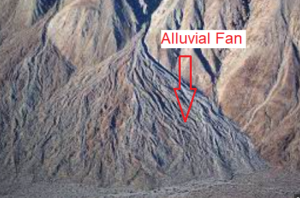
The alluvial material which flows down from mountains, accumulates at foot hills where the stream enters a plain. The deposition occurs due to abrupt changes in the gradient of the river valley. Such deposits spread out in the shape of flat fans, and are called “alluvial fans”. Usually, the course material is dropped near the base of the slope, while finer material is carried further out on the plain. Alluvial fans from various adjacent streams along a mountain may merge to form a long wedge of sediment called “alluvial aprons”.
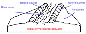
Flood Plains
During floods, a river overflows its bank and submerges the adjacent low-lying areas where deposition of alluvial material takes place. A wide belt of alluvial plains formed in this way on either side of a stream is called “flood plains”. It is so named because the floodplains get submerged.
The area behind the levees is poorly drained as water can not flow up the levees to join the river. The marshes thus formed, are called “back swamps”. A tributary stream often has to flow parallel to the mainstream until it can breach the levee. Such streams are called “Yazoo Tributaries”.
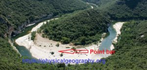
Point Bars
In meandering rivers, sediment deposits occur as point bars. The “point bars” are the crescent-shaped deposits, which occur at the inside bends of a river channel.
Deltas
“Deltas” are deposits built at the mouths of streams. The deltas are usually triangular in shape with their apex pointed upstrea. When a stream enters an ocean or lake, the currents of the flowing water dissipate quickly. This results in the deposition of series of sedimentary layers which make up the deltas. The material of most deltas is well sorted and many deltas are uniformly graded. The structure of a delta deposit is shown in the following image. It consists of three sets of beds: (i) bottom-set beds, (ii) foreset beds, and (iii) top-set beds.
- Bottom-set Beds: The thin horizontal beds, which overlie the ocean bottom are called “bottom-set beds”. They are mainly composed of fine-grained sediments, such as silts and clays.
- Foreset Beds: Foreset beds begin to form prior to the accumulation of bottom-set beds. These beds are composed of coarse sediment, which is dropped almost immediately when a river enters a lake or ocean. The foreset beds appear similar to crossbedding and their angle of slopes varies from 12° to 32° depending on the grain size of the material.
- Topset Beds: Foreset beds are covered by thin nearly horizontal top-set beds. These beds occupy the upper surface of the delta. They are composed of a mixture of coarse and fine materials.
Major rivers, such as the Ganges-Brahmaputra, form large deltas thousands of square kilometres in area. On large deltas, the main channel of the river divides to form several smaller branches, called “distributaries”. They discharge water in various paths to the sea.
Sand Dunes
The strong action of wind generally deposits sand in the form of mounds. These sand mounds are known as “Sand Dunes”. The sand travelling as a bed load in the wind accumulates wherever it meets any obstruction, such as a boulder or a bush. As the accumulation of sand grows, it traps even more sand. In this manner, dunes are created. Sand dunes have a gentle slope (5° – 15°) on the windward side and a steeper slope (20° – 30°) on the lee side. The height of sand dunes depends on the wind speed and the size of sand grains. Dunes of 30 meters in height are very common all through the globe. The sand dunes migrate slowly in the direction of wind movement. In some cases, they move as much as 20 meters per year. The migrating sand dunes may advance and cover farmland, erode cultivated lands, abrade crops, cover roads/railway tracks, etc. Sand dunes can be considered as a natural hazard. Their movement can be checked by planting vegetation.