Stream Erosion/Water Erosion refers to the process by which flowing water (rivers or streams) wears away the Earth’s surface, thus transporting away the sediments and shaping the landscape. Some prominent features of stream erosion are varied and can be observed in different forms. Here are some key features associated with stream erosion: Features of Stream Erosion (water Erosion).
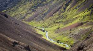
V-Shaped Valleys
Erosion by flowing water often results in the formation of V-shaped valleys as the stream cuts into the surrounding land. V-shaped valleys are carved out by the rivers in their youthful stages. Their shapes are of the letter of the English alphabet V. They are associated with gorges, canyons etc.
How does a V-shaped Valley start forming?
- First of all a river begins high up in the mountains and starts flowing quickly downhill, thus eroding the landscape vertically.
- The turbulent flow of the river water cuts a deep notch down into the landscape using hydraulic action, when the sheer force of the water gets into small cracks and breaks down the sides of the river valley. Corrasion (abrasion) also occurs which is when the river bed and banks are eroded by the load hitting them. Another type of erosion that happens is corrosion (solution) when the river water dissolves minerals from the rocks and washes them away.
- As the river erodes downwards the sides of the valley are exposed to freeze-thaw weathering, which loosens the rocks (some of which will fall into the river) and steepens the valley sides.
- The rocks which have fallen into the river assist the process of corrasion and this leads to further erosion.
- The river transports the rocks downstream and the channel becomes wider and deeper creating a V-shaped valley between interlocking spurs.
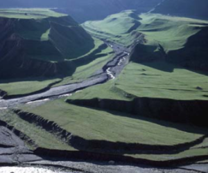
Meanders
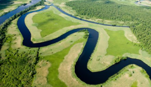
Meanders refer to winding, looping curves or bends in a river or stream. They are a natural feature of many rivers and are formed over time through the erosion and deposition of sediment. Meanders typically occur in the middle and lower reaches of a river, where the water flow is slower and the channel has a gentler gradient.
The process of meandering involves the erosion of the outer bank of a curve and the deposition of sediment on the inner bank. As the outer bank erodes, a cut bank is formed, and sediment is deposited on the inner bank, creating a point bar. Over time, the meander loop may migrate downstream, and new cutbacks and point bars form.
Meanders contribute to the overall complexity of a river system and play a role in shaping the landscape. They are often seen in floodplains and are important for aquatic ecosystems, providing diverse habitats for various plants and animals.
Entrenched Meanders
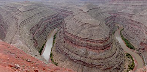
On many occasions, the land is uplifted. The uplifting of a mature stream would cause it to give up lateral erosion and revert to downcutting. Rivers of this type are said to be “rejuvenated”. When a meandering river is rejuvenated, it starts downcutting again. As a result, the meandering channel is deepened and the old meanders get entrenched into the bedrock. Such meanders are called “entrenched meanders”.
Oxbow Lakes
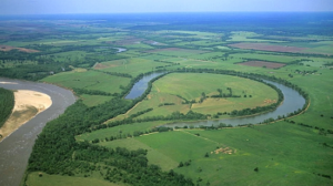
The crescent-shaped lakes by the sides of rivers are known as Oxbow Lakes. Oxbow lakes are the remains of the bend in the river. They are Stillwater lakes, meaning that water does not flow into or out of them. No stream or spring is feeding the lake, and it doesn’t have a natural outlet. Oxbow lakes often become swamps or bogs, and they often dry up as their water evaporates.
Formation of Oxbow Lakes: A curve, or a meander in a river results in the initiation of an oxbow lake. The meander becomes an oxbow lake along the side of the river when a river finds a different, shorter course.
They are generally formed in flat, and low-lying plains close to where the river falls into another body of water. On these plains, rivers often have wide meanders.

Meanders that form oxbow lakes have two sets of curves: one curving away from the straight path of the river and one curving back. The corners of the curves closest to each other are called concave banks. The concave banks erode over time. The force of the river flowing water wears away the land on the meanders’ concave banks.
The banks opposite the concave banks are called convex banks. The opposite of erosion happens here. Silt and sediment build up on convex banks. This build-up is called deposition.
Erosion and deposition eventually cause a new channel to be cut through the small piece of land at the narrow end of the meander. The river makes a shortcut. Oxbow lakes are the remains of the bend in the river.
River Terraces
Flat, elevated surfaces on the sides of a river valley, formed by the remnants of old floodplains. In geology, a terrace is a step-like landform consisting of tread (a flat or gently sloping geomorphic surface), and scarp/riser (a steeper ascending slope). The tread and the steeper descending slope (riser or scarp) together constitute the terrace. Terraces can also consist of a tread bounded on all sides by a descending riser or scarp. If a terrace is narrow, it is then called a bench.
Formation of River Terraces: A river terrace is formed by the fluvial deposition of a river. Long-lived river (fluvial) systems can produce multiple terrace surfaces in series throughout their geologic lifetime. When rivers flood, sediment deposits in the form of sheets across the floodplain and build up over time. Later, during river erosion, this sediment is cut into, or incised, by the river and flushed downstream. The previous floodplain is therefore abandoned and becomes a river terrace. A river terrace is composed of an abandoned surface, or tread, and the incised surface, or riser.
Waterfalls
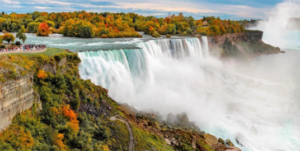
The falling of stream water from a height is a “waterfall”. Waterfalls occur at places where the stream profile makes a vertical drop. Such a situation is usually found where gently inclined, erosion-resistant beds are overly the non-resistant beds. The softer rock is eroded fast, while the harder one offers resistance and forms a ledge at a height, from which the stream water falls down deep into the gorge. When the water falls over the ledge, it erodes the less resistant bed of the cliff. Due to this undercutting, a portion of the upper resistant bed breaks off and the waterfall retains its verticle cliff, while it gradually moves upstream. Niagara Falls (USA) has retreated 11 km upstream since its formation.
Potholes
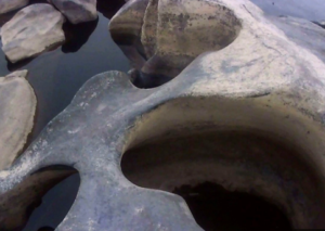
Potholes are circular and deep holes, cut into solid rocks by sand grains and pebbles, swirling in fast eddies. They are commonly found on a channel’s floor. The first thing that comes to mind is probably the potholes we find in the middle of the road. River potholes are somewhat alike.
They are holes along river beds. Of course, what we need to know is how these are formed. So a river bed starts off with possibly a small natural crack. When small rocks and pebbles get caught in a circular motion, like a whirlpool, it causes a drilling action into the river bed at that crack. It is a drilling action because there is an abrasion between the small rocks and the river bed. Over time, this drilling action continues and forms a pothole. The size of a pothole varies, mostly depending on the amount of time the drilling action occurs. They can be many centimetres wide and deep.
Incised Meanders
Vertical erosion deepens the stream channel, leading to the formation of incised meanders. incomplete…..(coming soon)
Stream Piracy
A process where one stream captures the flow of another, usually through erosion and the diversion of water. incomplete…..(coming soon)
Braided Streams
Streams with multiple interconnected channels separated by bars and islands, often characterized by a high sediment load. incomplete…..(coming soon)