Although historical and process studies are dominant over modern geomorphological enquiry, particularly in English-speaking nations, however, other types of study also exist. For example, structural geomorphologists, who were once very influential, argued that underlying geological structures are the key to understanding many landforms. Geomorphology types are broadly categorized by the dominant forces shaping landforms, including Tectonic (internal forces like folding, faulting, Fluvial (rivers/ streams), Glacial (ice), aeolian (wind), and Marine (ocean waves). Specialized branches also focus on Climate (climatic zones), Planetary (other worlds), Submarine (ocean floor), and Human/Anthropogenic impacts, studying how these varied processes create Earth’s diverse landscapes. We need to study tectonic geomorphology to understand the mechanism of plate tectonics. To study underwater geomorphology, we need to study submarine geomorphology. The study of geomorphology has further been divided into different branches in order to better understand some of the specific landforms. These subfields are: applied geomorphology, tectonic geomorphology, submarine geomorphology, climate geomorphology, planetary geomorphology, glacial geomorphology, aeolian geomorphology, etc.
Applied Geomorphology
Applied geomorphology is largely an extension of process geomorphology. It tackles the way in which geomorphic processes affect, and are affected by, human activities. Process geomorphologists, armed with their models and geomorphic tools, have contributed to investigate the outstanding problems associated with the human impacts on landscapes. Applied studies investigate coastal erosion and beach management, soil erosion, the weathering of buildings, landslide protection, river management and river channel restoration and, the planning and design of landfill sites.
Other process geomorphologists have tackled general applied issues. Geomorphology in Environmental Planning, for example, considered the interaction between geomorphology and public policies, with contributions on rural land-use and soil erosion, urban land-use, slope management, river management, coastal management, and policy formulation. Geomorphology in Environmental Management, as its title suggests, looked at the role played by geomorphology in management aspects of the environment. Geomorphology and Land Management in a Changing Environment focused upon problems of managing land against a background of environmental change. The conservation of ancient and modern landforms is an expanding aspect of applied geomorphology.
Tectonic Geomorphology
Tectonic Geomorphology explains the interaction between tectonic and geomorphic processes in regions where the Earth’s crust actively deforms to reshape landscapes. Updated measurements and understanding of rates of tectonic and geomorphic processes have revitalised it as a field of enquiry. Tectonic Geomorphology helps reveal clues about seismic hazards, volcanism, mountain building, and long-term geological history using tools from structural geology, seismology, and dating techniques. It examines features like fault scarps, mountain fronts, and marine terraces to quantify uplift rates, reconstruct tectonic histories, and assess seismic risks in active regions, integrating various Earth science disciplines for a holistic view of landform evolution.
It is a highly integrative and stimulating field that uses techniques and data obtained from studies of structure, geomorphology, geochronology, seismology, geodesy, and Quaternary climate change.
Submarine Geomorphology
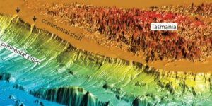
The subject of Submarine Geomorphology investigates the morphology and evolution of undersea landforms, and the processes responsible for their formation as well. Submarine geomorphology investigates erosion and depositional processes, volcanic activities, sediment movement and deformation, fluid migration, and anthropogenic impacts on seafloor landforms. The geomorphologists from different disciplines are encouraged to interact and employ state-of-the-art seafloor exploration instruments and analytical techniques, like high resolution bathymetry, side scan sonar, seismic reflection profiling, AUV, ROV, seabed sampling, seafloor classification, geomorphometry, in order to better understand and explain the most extensive geomorphic system on our planet.
Sub-marine Geomorphology helps the scientists to investigate morphology and evolution of seafloor landforms, and the processes responsible for their formation.
The main objectives of Submarine Geomorphology are:
- to establish submarine geomorphology as a field of research and investigation.
- to introduce techniques and discoveries made by submarine geomorphologists with the rest of the earth scientists and professionals.
- to encourage new students in geomorphology to develop interests, knowledge, and skills in the field of submarine geomorphology.
- to promote coordination between terrestrial and submarine geomorphologists to share mutual knowledge and techniques.
- to identify the key problems that need to be addressed by submarine geomorphologists in the near future.
Climatic Geomorphology
The chief climatic geomorphology exponents are from either French or German. Their arguments enjoy superiority on the rest of universally accepted observation that each climatic zone (tropical, arid, and temperate) engenders a distinctive suite of landforms. Climate does strongly influence geomorphic processes, but it is doubtful that the set of geomorphic processes within each climatic zone creates different landforms. The current consensus is that, owing to climatic and tectonic change, the climatic factor in landform development is more complicated than the geomorphologists have suggested on occasions.
Glacial Geomorphology
In Glacial Geomorphology, we study the role of glaciers and ice sheets in shaping the Earth’s surface. Glaciers and ice sheets do their job by means of erosion, transportation, and deposition. These three processes are the most important agents of shaping the Earth’s surface. Different types of landforms (U-shaped Valleys, Moraines, Cirques, for example) are the result of erosion, transportation, and deposition. Glacial Geomorphologists analyse, how ice movement weathers, erodes and transports vast amounts of sediment, and finally deposits it as distinctive features like drumlins and till plains as the ice melts. By mapping these landforms, scientists reconstruct glacier behavior, revealing crucial information about climate history and future sea-level rise.
Glaciers work through four stages;
- Weathering: Weathering is the process of detachment of particles from the bedrock.
- Erosion: Ice scrapes bedrock (abrasion) and plucks away chunks, creating features like polished surfaces, rock flour, and striations (grooves).
- Transport: Glaciers carry sediment (from clay to boulders) on, within, and beneath the ice (supraglacial, englacial, subglacial).
- Deposition: When ice melts, it drops sediment (till) in distinctive forms, influenced by meltwater.
Planetary Geomorphology
Planetary Geomorphology is thriving branch of geomorphology, which deals with the study of landforms on planets and large moons having a solid crust, for example, Venus, Mars, and some terrestrial (solid) moons of Jupiter and Saturn. Surface processes on other planets and their satellites are determined, materially, by their mean distance from the Sun, which dictates the annual receipt of solar energy, their rotational period, and the nature of the planetary atmosphere. The processes, so far observed, include weathering, aeolian activity, fluvial activity, glacial activity, and mass movements.
Karst Geomorphology
Karst is a topography formed from the dissolution of soluble carbonate rocks such as limestone and dolomite. It is characterized by features like poljes above and drainage systems with sinkholes and caves underground.
A landscape producing ridges, towers, fissures, sinkholes and other characteristic landforms.
Thus, the karst geomorphology deals with the studies of porous landscape and underground system having features like sinkholes, caves, underground streams, and distinctive surface pattern formed by dissolusion of the soluble materials (limestone, dolomite, and gypsum) by the action of mildly acidic water. The process of karst forming is known as Karstification. Karstification leads to complex drainage systems where surface water often disappears underground, making these areas crucial for groundwater but also vulnerable to pollution. Key landforms include dolines, poljes, and cave formations like stalactites and stalagmites. Karst geomorphology is crucial for better understanding a specific and unique landscape, which a common geomorphologist is unable to understand.
Biogeomorphology
Biogeomorphology also known as ecogeomorphology is the study of interactions between organisms and the development of landforms, and are thus fields of study within geomorphology and ichnology. Organisms affect geomorphic processes in a variety of ways. For example, trees can reduce landslide potential where their roots penetrate to underlying rock, plants and their litter inhibit soil erosion, biochemicals produced by plants accelerate the chemical weathering of bedrock and regolith, and marine animals cause the bioerosion of coral. The study of the interactions between marine biota and coastal landform processes is called coastal biogeomorphology.
Aeolian Geomorphology
Some of the landforms are developed by the action of wind. A geomorphological study of lanforms, which are shaped by wind, focusing how wind brings erosion on bedrocks, transports sediments, and deposits these transported particles. Aeolian Geomorphology is not confined to the geomorphic features of earth, but also discussed the landforms shaped by the action of winds and gases on other planets. Most aeolian features include sand dunes, loess deposits, ventifacts, and desert pavements, formed through processes like abrasion (wind-blown particles grinding surfaces), deflation (lifting fine sediment), and saltation (hopping particles). It’s crucial for understanding arid landscapes, dust storms, and planetary surface evolution.