A strait is a narrow waterway between two lands, which two connects two major waters (seas/oceans). A strait is geographically important, as hundreds of vessels pass through the strait daily. Straits are also important because of their being shortest sea routes. Here is a list of the world’s straits, and their geographical and navigational importance as well.
Malacca Strait
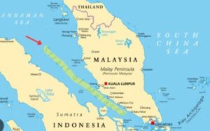
The Malacca Strait is 800 kilometer long, but narrow (2.5km) water channel, that links Andaman Sea (Indian Ocean) with the South China Sea (Pacific Ocean). It is located between lands of Sumatra (Indonesia) and Malaysia. It is one of the world’s most important, and busiest shipping lanes, carrying over 30% of global maritime trade and roughly 70–80% of China’s and Japan’s energy imports, it is a vital global chokepoint facilitating enormous economic traffic. This strait is of particular importance for China and Japan. If it is blocked, rerouting ships through the Sunda or Lombok straits would be immensely costly and time-consuming, significantly increasing shipping costs and times. Moreover, 20% of the world’s LNG (Liquefied Natural Gas) trade is carried out through the Strait of Hormuz.
Because it is only 2 miles wide for both inbound and outbound traffic, it is highly susceptible to blockades and military tension, which causes immediate spikes in global energy prices. A disruption can trigger global economic instability by impacting the supply of energy and raw materials.
Strait of Gibraltar
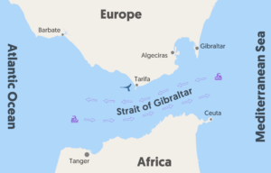
The Strait of Gibraltar is located between Morocco (Africa) and Spain (Europe). It is a 14-kilometre-wide sea part that connects the Mediterranean Sea with the Atlantic Ocean. It is one of the world’s busiest shipping lanes, with deep, fast-moving, two-way currents and depths of up to 900 meters. It separates Europe (Spain/Gibraltar) from Africa (Morocco) and is essential for connecting Asian, European, and African markets. The Strait is a major artery for global shipping, with approximately 100,000 vessels transiting the route annually (around 300 ships utilise the passage daily), carrying about 10% of global maritime trade. The Strait is an important shipping route from the Mediterranean to the Atlantic. Ferries operate between Spain and Morocco across the Strait, as well as between Spain and Ceuta and Gibraltar to Tangier. Proposals exist for a Strait of Gibraltar crossing by bridge or tunnel.
Strait of Hormuz
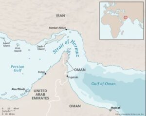
The Strait of Hormuz is a narrow point of the sea located between the Persian Gulf and the Gulf of Oman. The Islamic Republic of Iran is located to the north of the Strait, while the southern coast is the domain of the Musandam Peninsula. The peninsula is shared by the United Arab Emirates and the Musandam Governorate (an exclave of Oman).
The Strait of Hormuz is the world’s most critical energy chokepoint, with roughly 20–30% of global oil and LNG passing through its narrow lanes daily. Situated between Iran and Oman, it is the only sea route for Persian Gulf states to transport oil to Asia and the West, making its security crucial to global energy prices. About 60-80 % of the oil shipment to China and Japan is carried out through the Strait of Hormuz.
Bering Strait

Connects the Arctic Ocean and the Bering Sea (Pacific Ocean); between Alaska and Russia. It is a narrow, shallow waterway, roughly 85 km (53 miles) wide and 50 m deep, separating Chukotka (Russia) from the Seward Peninsula(Alaska). It connects the Arctic Ocean to the Pacific Ocean (Bering Sea). The strait acts as a crucial marine corridor for wildlife and, historically, for human migration, located south of the Arctic Circle. The Bering Strait is an important junction for ecology, climate, history, and international strategy. It connects the Pacific and Arctic Oceans, making it a vital conduit for marine life and maritime traffic.
Sunda Strait
The Sunda Strait is a vital waterway of about 26-100 km, located in Indonesia, and separates the Islands of Sumatra and Java. This water body connects the Java Sea (Western Pacific Ocean) with the Indian Ocean. The strait is known for the volatile Krakatoa volcano; it is a treacherous shipping lane featuring strong currents and shallow areas. Historically significant for trade, it serves as a strategic maritime route.
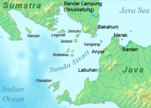
The Sunda Strait is a critically important, roughly 120-kilometre-long waterway within Indonesia. Being located between the islands of Sumatra and Java, it links the Indian Ocean with the Java Sea. Although it is less important w.r.t international trade, it is still important because it stems from its role as a key maritime artery, a major hub for regional economic activity, and a strategic point of interest in international trade and military navigation.
Bab-el-Mandeb
The Bab-el-Mandeb or Strait of Mandeb is a strait and a major global chokepoint connecting the Red Sea and the Gulf of Aden (part of the Arabian Sea), between Yemen (a country in Arabian Peninsula) and Djibouti and Eritrea in the Horn of Africa. The Bab el-Mandeb Strait is a very important maritime trade artery for global energy, trade, and geopolitical strategy, serving as the southern gateway to the Suez Canal. The Bab el-Mandeb the Strait, which is crucial for the countries whose economies depend on the transit of oil, natural gas, and commercial goods between the Indian Ocean and the Mediterranean Sea.
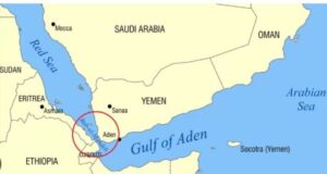
As a vital chokepoint connecting the Gulf of Aden to the Red Sea, its security directly impacts several key nations. Countries like Yemen, Egypt, Djibouti, Eritrea, Saudi Arabia, and China largely depend on the Strait of Mandeb for their energy import and export.
Taiwan Strait (Formosa)
The Taiwan Strait, formerly known as Formosa, connects the South China Sea and East China Sea, thus located between China and Taiwan. The width of the strait is 180-km and it provides a major geopolitical hotspot to international marine trade. Apart from being a crucial navigation route, it is also an important fishing ground, which is highly productive but often restricted due to geopolitical tensions between China and Taiwan. Over 1,300–2,000 Chinese vessels are frequently operating there, occasionally acting as a maritime militia. Moreover, Typhoons in the Taiwan Strait (TS) are also dangerous. The powerful storms that frequently traverse this narrow corridor pose significant hazards, including flooding, high wave heights (up to 5+ meters), and damaging winds. These systems can cause massive power outages and transport shutdowns, as seen with the severe impact of Typhoon Gaemi in 2024 and the 2025 impact of Typhoon Podul.
Dover Strait
The Dover Strait is named after the county of Dover in Kent (South England). It is famous as a major ferry port and for its iconic White Cliffs. Dover is also known as “Lock and Key of England,” as it features the extensive medieval Dover Castle and Secret Wartime Tunnels, which acted as a key defensive site against European invaders for centuries.
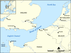
The Strait of Dover (Dover Strait) is the narrowest point of the English Channel. It connects the English Channel (Atlantic Ocean) with the southern part of the North Sea. It separates South East England from Northern France. Historically, it is also known as the Dover Narrows, the strait at the narrowest part of the English Channel, being the shortest distance across the strait, at 33.2 km. The key territories directly bordering the strait are the county of Kent in England to the northwest and the Hauts-de-France region (formerly Nord-Pas-de-Calais) in France to the southeast. Between these points lies the most popular route for cross-channel swimmers. The entire strait is within the territorial waters of France and the United Kingdom, but a right of transit passage under the United Nations Convention on the Law of the Sea allows vessels of other nations to move freely through the strait.
Palk Strait
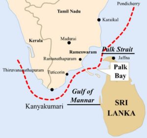
It connects the Bay of Bengal in the northeast with Palk Bay and the Gulf of Mannar in the southwest. Due to its shallow depths—generally ranging between 9 and 13 meters—and an abundance of coral reefs, it is impassable for large commercial ships, which must navigate all the way around Sri Lanka.
Bass Strait
Bass Strait is a turbulent 150-mile-wide sea channel separating mainland Australia from the island state of Tasmania, connecting the Indian Ocean to the Tasman Sea. Formed by rising sea levels at the end of the last ice age, the strait is notorious for its hazardous navigation, yet it serves as an essential, rich maritime highway and natural gas reserve.
Bosphorus Strait
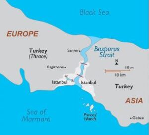
The Bosphorus Strait is a vital 30-kilometer natural waterway in Turkey that connects the Black Sea to the Sea of Marmara. It physically divides Europe and Asia while running directly through Istanbul, making it uniquely famous as the world’s only city that spans two continents.