The theory of Plate Tectonics has evolved from Harry Hess’s concept of “seafloor spreading”. He proposed this concept in the early 1960s. Hess’s hypothesis was accepted when Vine and Mathews used it in explaining linear magnetic anomalies of the ocean basins. In 1967, W. J. Morgan, and J. T. Wilson extended the idea of Hess and produced the theory of plate tectonics. The factors, which led to the theory of plate tectonics were: (i) mapping of ocean floor, (ii) study of seismic data, and (iii) pattern of anomalies of the earth’s magnetic field. This theory has now presented an explanation for many of the complex geological processes, such as volcanic activities, earthquakes, mountain building, and continental drift.
Crustal Plates
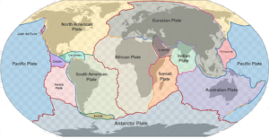
The entire Earth’s surface is composed of several rigid but relatively thin plates. These plates are between 100-150 km thick and carry both continental and oceanic crust with them. They are continuously in motion with respect to one another.
The plates vary in size. There are about 20 crustal plates on the earth’s surface, out of which seven are very large. The large plates are: (i) the North American Plate, (ii) the South American Plate, (iii) the Eurasian Plate, (iv) the African Plate, (v) the Indo-Australian Plate, (vi) the Pacific Plate, and (vii) the Arctic Plate. These plates are separated by ridges, transform faults, and trenches.

The plates slide over a partially molten plastic layer called the “asthenosphere”. The asthenosphere occurs below the lithosphere in the upper mantle at a depth between 100-200 km. In this zone, the velocity of shear waves drops to a minimum range. Its plastic behavior may be due to the increased temperature and pressure existing at greater depths. The asthenosphere is believed to be the site of convection cells.
Plate Boundaries
Almost all seismicity, volcanicity, and tectonic activity are localized around the plate margins. Hence boundaries between different plates are of particular interest. Depending on the relative motions of adjacent plates, the plate boundaries are classified into three groups: (i) divergent boundaries, (ii) convergent boundaries, and (iii) transverse boundaries. Let us distinguish between a plate boundary and a plate margin. The zone of motion between two plates is called “plate boundaries”, and a marginal part of a single plate is known as the “plate margin”. Two plate margins meet at a common “plate boundary”.
Three types of Plate Boundaries
Divergent Boundary

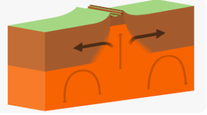
Divergent boundaries are also called “Constructive Zones” because, in these zones, the new crust is continuously created. Divergent boundaries occur at oceanic ridges. The “divergent boundaries” are boundaries along which plates move away from each other. In the process of plate separation, the magma rises from the asthenosphere and fills the gap thus created. In this way, a new crust is created along the trailing edges of the diverging plates. This phenomenon is called “Sea Floor Spreading”. Such boundaries are characterized by basaltic igneous activity, shallow-focus earthquakes, and high rates of heat flow.
Thus the oceanic ridges are the newest part of the Earth’s crust. The oldest crust is found near the oceanic trenches, where it slides down into the mantle. The plates move from ridges and travel like a conveyor belt towards trenches where they are destroyed. Plate boundaries at which the net effect of motion is to generate crust are called “sources”. The rate of seafloor spreading at ridges ranges from less than 1.0 centimeters to 6.0 centimeters per year.
Convergent Boundary

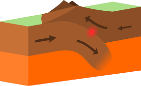
The “Convergent boundary” is a boundary along which two plates approach each other and the leading edge of one slips down under the other at an angle of about 45 degrees. These boundaries are also called “destructive boundaries” or “subduction zones”. They occur at the deep trenches. The dipping plate sinks into the asthenosphere, where the lithosphere melts to produce magma. Thus trenches are the areas where plate edges are destroyed. The plate boundaries at which the net effect of the motions is to destroy surface area are called “sinks”. Since the surface area of the earth does not change, the amount of crust created at the oceanic ridges is balanced by that destroyed at the trenches.
The convergent boundaries are characterized by basaltic and andesitic volcanism, deep-focus earthquakes, and fold mountain ranges.
Transform Boundary

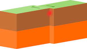
“Transform fault boundaries” are boundaries along which plates slide past one another and there is no production or destruction of lithosphere. The transform faults run in the direction of the plate movement and offset oceanic ridges. The margins at which the plates neither gain nor lose surface areas, are called “conservative boundaries”. The transform faults are characterized by shallow-focus earthquakes with horizontal slips.
Although most of the transform faults occur in the oceanic crust, a few are found within continents, such as the San Andreas Fault (South West USA).
Plate Margins
A plate may carry either continental or oceanic crust or both. However, only those margins, which have oceanic crust can participate in the main process of plate growth and destruction. The important events associated with plate margins are as follows;
- The continental crust can not be subducted. It tends to remain floating because this crust is thicker and more buoyant. Where two plates with continents at their leading edges converge a collision takes place. As a result, the crust thickens to form great mountain ranges like the Himalayas. In such a case the relative motion between the two plates ceases and they unite to form a larger single plate.
- Where a continental crust converges with the oceanic crust, the less dense continental mass remains floating while the more dense oceanic crust sinks into the mantle along the line of the oceanic trench. Such a process operates at the Peru-Chile trench where the Nazca Plate (oceanic) sinks under the continental plate of South America.
- Where two oceanic plates converge, one of them is subducted. The magma produced due to the melting of the dipping plate, rises to the surface (oceanic floor) creating volcanoes. Island arcs are produced as a result of the continuation of this activity.
- The spreading process which operates at oceanic ridges, produces only the thin oceanic crust and not the thick and mineralogically different crust of the continent.
Changes in shape and size of plates
Normally plates change both in size and shape. However, there are two conditions in which their size will not alter: (i) when the rates of growth and destruction on opposite sides of a plate exactly balance each other, and (ii) when a plate is surrounded, on all sides by conservative boundaries.
A plate that has constructive margins on the two opposite sides will expand in size and therefore its shape will change. The African plate is a good example of this type. This plate is bounded on the west by the Mid-Atlantic Ridge and on the east by the Indian Oceanic Ridge. Both of these ridges are active centers of spreading. Thus this plate must be expanding in the east-west direction.
The earth is of constant surface area. It demands that if the area of some plates increases, that of others must decrease. Hence, in theory, it is possible that a place may be, completely, destroyed, and mid-oceanic ridges and deep ocean trenches may migrate freely with respect to each other.
Opening and Closing of Oceans
Plates change both in size and shape. This means that new plates can form by breaking up or welding together other plates. This results in the birth and death of oceans. The process of opening and closing of oceans may be outlined as follows:
- An ocean grows where the process of seafloor spreading is under progress and shrinks where continents force the ocean floor to slide down into the trench. The Atlantic is an example of a growing ocean while the Mediterranean is that of shrinking.
- A shrinking ocean disappears altogether when the continental masses converge and join with each other.
- The birth of a new ocean takes place with the breaking of a continent. This breaking occurs due to the formation of a new spreading center. The Red Sea is believed to be the site of a recently formed spreading center. The birth of the Red Sea took place when the Arabian Peninsula separated from Africa and moved towards the northwest.
You may like to read: